Underground Utility Locating / Mapping
Combining Concrete X-Ray Scanning and Ground Penetrating Radar Services, Inspection Resources and locate and map underground utilities quickly and efficiently.Avoid unpleasant underground surprises.
Utilize our X-Ray Scanning and GPR Services to locate and map underground utilities quickly and cost effectively.
With the majority of construction projects in Southern California located on infill, campus or urban sites, nearly every project requires assessing pre-existing conditions. Unfortunately, as underground utility services are added, moved, or changed, as-built documents often aren’t updated. Utility companies typically only document where their lines are buried. These factors add up to high risk when it comes to excavating without an underground utility assessment.
To offset this risk, iR uses a range of nondestructive testing methods to locate and mark underground utilities.
Because “as-builts” were only accurate ONCE upon a time.
As-builts, which should provide an accurate map of site utilities, are often incorrect. Unfortunately, when relocations and additions are made, plans are often not updated. Damages to in-service utility lines during excavation can not only be expensive to repair, but are time consuming and potentially deadly.
Always best to test before you dig!
Identification:
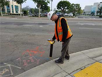
Underground utility services include Identifying concealed underground objects such as piping, telecommunications cable and electrical power lines. Locations are identified using three primary methods after a thorough visual assessment of the subject areas & X-Ray In-House.
- Electromagnetic tracing is the most common and cost effective method for locating utilities, and is the first step in a comprehensive investigation.
- GPR/Below-ground Radar is used on areas where detailed information is required. Radar identifies the horizontal location and depth of service lines such as water, sewer, communications, and power.
- Potholing, a method of vacuum excavation, can then be used where it is necessary to identify exact horizontal and vertical locations of intersecting utilities, the type of material, and utility size. Detailed pothole logs and photo documentation is provided for permanent documentation.
Underground Utility Locating
With our ground-penetrating radar, electromagnetic methods along with potholing, iR technicians can accurately identify buried utilities including sewer and septic systems, water pipes, and lines for gas, electricity, telecommunications and cable TV.
Underground Utility Marking
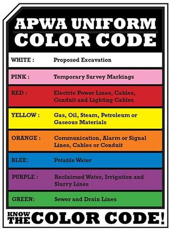
Once identified, underground targets are marked using recognized APWA paint markings and/or flag markers to identify specific uses (e.g. gas, water, sewer, communications, and power).
Underground Utility Reporting
We provide concise reports for all our projects and will customize the level of documentation based upon specific client needs. Reports generated by iR not only include the actual scan data, but also photographs and clear text explanations of results.
Contact Us
Let’s work together! Inspection Resources is the premiere Concrete X-Ray and Ground Penetrating Radar Service provider in Southern California.
Your time is money. We are on site within 24 hours for more than 90% of our projects. Once testing is complete, we generate reports and distribute them digitally, often in near real time, getting the information to the people working on site as quickly as possible to avoid any delays.
Send us a message or call us today to discuss how we can help you.
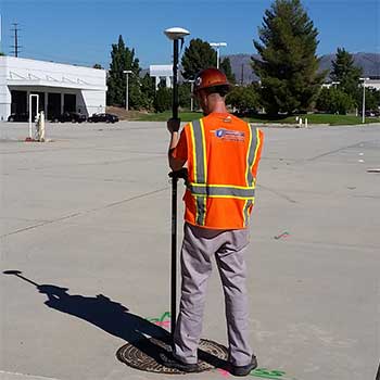
Mapping Services
Mapping: Reports can also be provided in CAD format making information easy to use for designers and engineers. iR technicians use GIS mapping devises that collect geospatial data available to them. The information is processed and accurately plotted in a CAD format. This efficiently provides our clients with solutions to plan, manage, and complete projects with our GIS mapping services.