UG Locating Utility Locating / Mapping
Katella High School – Underground Utility Locating and Mapping ProjectCASE STUDY
Underground Utility Locating & Mapping
PROJECT NAME AND LOCATION
Katella High School 2200 E. Wagner Ave. Anaheim, CA 92806CLIENT:
Anaheim Unified High School DistrictObjective
The district was in the design phase of a storm water infiltration system which will be installed.
What is a storm water infiltration system?
A storm water infiltration system is an economical means for managing rain water runoff. Most developed areas today are designed to waste water, funneling rain down gutters and drain pipes rather than allowing it to soak into the ground where it can recharge the water table. In addition, the large amount of pavement on streets, parking lots, and playgrounds contributes to the degradation of water quality. When rainwater flows across paved surfaces, it often picks up pollutants and particulates and then carries them into the nearest lake, river, or ocean.
Many schools around the world are trying to reverse this trend and teach their students about improving local water systems.
The goal was to provide thorough Underground Utility Locating and Mapping services in order to verify existing (but very old) as-built drawings as well as provide additional information on other utilities which may not be reflected in their current as-built drawings.
Special Circumstances?
This was an active high school. All work needed to be performed after normal school hours or while class was in session. A schedule was coordinated with the district and school faculty to ensure that our crews could complete the work in a timely manner as well as not to disturb classrooms in session during the weekdays.
Opportunity to Achieve/Challenge to Overcome
The goal was to mitigate any potential change order / cost overruns during the construction phase if/when unanticipated utilities were encountered along the trench path of the infiltration system. This would minimize or eliminate an RFI process delay changes in the project scope mid-stream resulting in pushing costs over-budget.
Let’s work together! Schedule an appointment.
Methods Utilized
Underground Utility Locating:
Our technicians began by reviewing the existing as-built drawings as well as performing a visual survey of visible utilites such as lids, risers, vaults, pull-boxes, etc.. along the intended trench path. This process helps identify access points for tracing the various utilities.
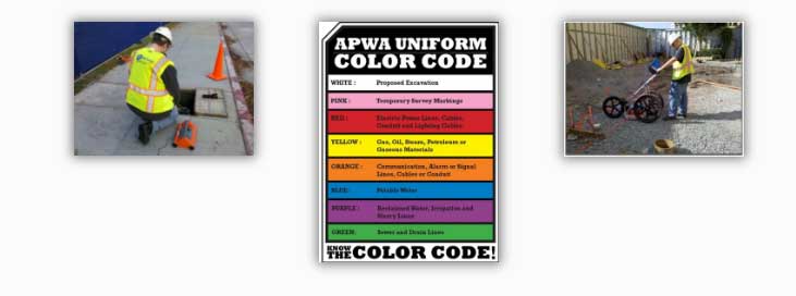
Electromagnetic Locating Devices as well as Ground Penetrating Radar (GPR) were used to accurately detect the utilities. All utilities were marked directly on the test surface in the appropriate APWA color code.
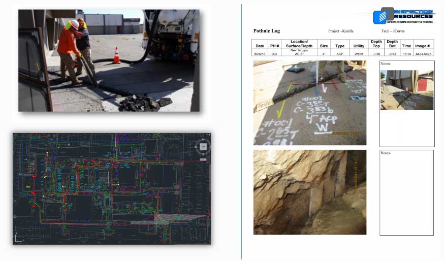
Potholing – Vacuum Excavation
In highly congested area(s), Vacuum Excavation methods were used to positively identify each utility type as well as their depth. Detailed Pothole Logs were provided along with photographs for permanent record.
Final Deliverables
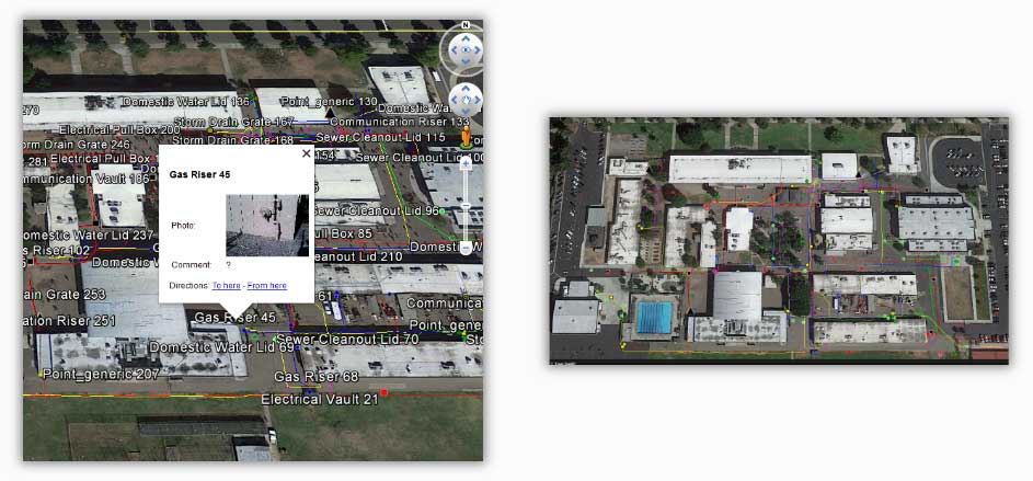
Finally, all of the results were mapped showing the appropriate APWA color designation for each utility along with pertinent photographs output in .KMZ format. The format uses the free download software of GOOGLE EARTH. This provides for a quick reference of all the utilities in an easy to use format
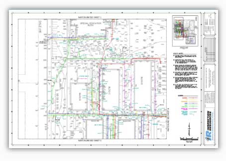
CAD File Output
In addition to .KMZ output to GOOGLE EARTH, a CAD file layer was provided on the client provided Topography site map for permanent record. The project planning team was able to proceed with an RFP to contracting firms with a comprehensive CLASH detail for the planned trenching operations so that any potential logistical issues could be dealt with up front prior to start of work.